

Welcome to the Great Southwest road trip.
This week I’m offering up another complete vacation itinerary. This road trip, which is mostly in Utah, will take you to some of the most spectacular scenery on the planet. It visits five national parks – seven if you take two optional side trips. The trip can be taken any time, although it’s ideally suited for April-May and September-October. Winters can be cold, and summers are very hot. As you can see from the accompanying photos, I like visiting this country in winter.
This is such a long post that I’ve divided it into two (see below). If this looks like your kind of road trip, you’ll want to return to this post when you’re ready to plan your trip. It will be posted in the archive under February 2016.
Rather than recommend a day-by-day itinerary, I’ve broken up the trip by destination to destination, with routing and mileages in between. Your total trip length will vary based on how long you stay at each destination.
Where to begin the Great Southwest road trip
My Great Southwest road trip route begins in Las Vegas, which is an ideal starting point if you live in California. Here are three other alternatives:
- From the midwest or eastern U.S.: Take I-70 through Denver and across the Rockies. Just beyond the Utah border, take exit 204 and follow SR 128 to Moab, where you’ll join the route. By the way, SR 128 is one of my 25 most scenic highways.
- From Texas and the south: Follow I-40 and I-25 to Santa Fe, then take US 84 to Pagosa Springs, Colorado. From there, US 160 will take you to Cortez, where you’ll turn right on US 491 to Monticello, an hour’s drive from Moab. Consider an optional side trip to Mesa Verde National Park, which is right on your way.
- From the northwest: Take I-84 to Ogden, Utah, then jog south on I-15 to Provo. From there, follow US 6 to Green River. Moab is an hour away via I-70 and US 191.
In Part One of this post, I’ll cover Las Vegas to Moab. The second part begins in Moab, including Arches and Canyonlands National Parks. If you’re beginning the route at Moab, start with Part Two, then come back to this part for the remainder of the itinerary. Part Two will be posted on Sunday, February 28.
If you’re an AAA member, you’ll want a copy of the Automobile Club of Southern California’s Guide to Indian Country –the best map of the area. You can get it at any ACSC office; your local AAA office can probably order it for you.
Las Vegas to Zion National Park – 201 miles
As much as I love Nevada’s Valley of Fire State Park, I’d recommend skipping it on this itinerary. You’ll be seeing plenty of red sandstone formations later on. From Las Vegas, it’s a straight shot on I-15 all the way to Utah. The interstate cuts across the far northwest corner of Arizona via the spectacular Virgin River Gorge. Ten miles beyond the Arizona-Utah border is the city of St. George – the biggest city along the tour route. Just beyond St. George, take Exit 16 onto Utah SR 9, which will take you right into the park.
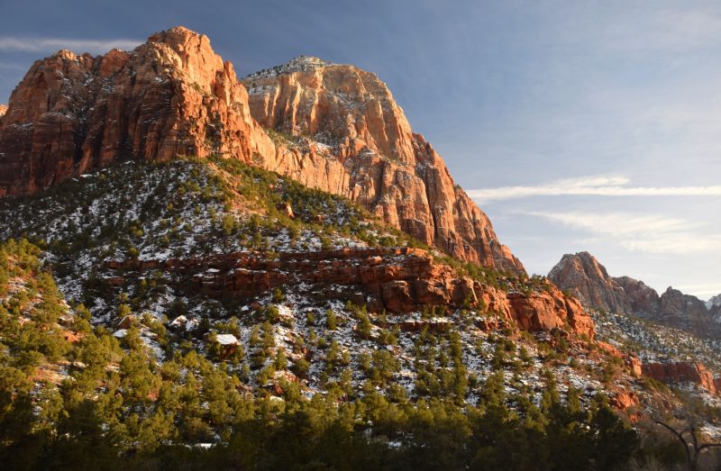
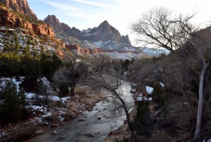
The main attraction in Zion is the canyon of the Virgin River, which flows between near-vertical walls of reddish sandstone. The scenery is awesome! You’ll find great hiking here; at a minimum, take the Weeping Rock and Gateway to the Narrows Trails. Stop at the visitor center for information on longer hikes, including the famous Zion Narrows trip.
Zion is a very popular park, and access to the canyon is restricted during busy periods. The 7-mile-long scenic drive is closed to private vehicles March 12-October 31 and on weekends in November. The park provides a free shuttle; you can get on or off at multiple stops along the way. My favorite time is winter, when I can drive anywhere I please and avoid crowds. The park entrance fee is $30 per car. There’s a lodge in the canyon, but you’ll do better staying in the town of Springdale just outside the park. Two campgrounds are in the park; at least one stays open year-round. For more information, go to www.nps.gov/zion/index
Zion National Park to Bryce Canyon National Park – 80 miles
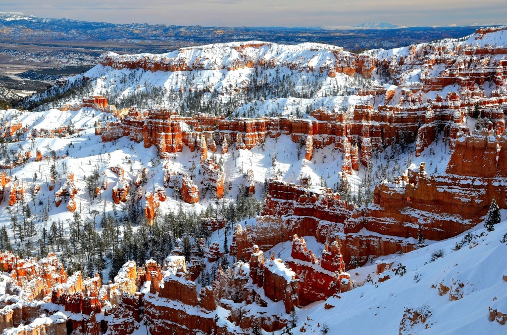
Bryce Canyon is fairly close to Zion, but the two parks are very different. At Zion, you’re mostly looking up at the scenery, while at Bryce you’re looking down. It’s not really a canyon. Instead, it’s the edge of a high plateau that’s been eroded into vividly colored formations – the world’s largest collection of fanciful “hoodoos.”
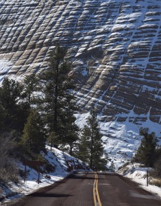
Let’s continue our Great Southwest road trip. From the Zion National Park Visitor Center, cross the Virgin River bridge and continue eastward. The road switchbacks up a steep cliff, with turnouts offering spectacular views of the canyon. You then enter the 1.1-mile Zion-Mt. Carmel Tunnel, built in 1930. When you exit the tunnel, you’re in a different world of oddly eroded cross-bedded sandstone that looks like nowhere else I’ve ever been. The highlight of this section is Checkerboard Mesa (pictured). Continue on SR 9 to a T-intersection, where you’ll head north on US 89 for 43 miles. Next, turn right onto SR 12, which takes you to the turnoff for Bryce Canyon National Park.
Bryce Canyon’s park road leads 19 miles along the plateau rim past numerous viewpoints. For me, the best viewpoints are Sunrise Point, Bryce Point and Sunset Point – all close to the visitor center. These offer the most wildly eroded formations, endless views and trailheads if you want to hike among the formations. Please keep in mind that the trailheads are over 8,000 feet in elevation, and the hike back to the trailhead is uphill all the way. The scenic drive beyond these viewpoints is usually closed by snow in winter.
Like Zion, Bryce Canyon operates a shuttle system during busy periods, but this one is voluntary. As at Zion, you’ll find a campground, as well as a lodge you should avoid – nice lodging, including the venerable Ruby’s Inn, can be found just outside the park gate. Bryce Canyon’s entry fee is $30 per car.Web site: www.nps.gov/brca/index
Bryce Canyon to Capitol Reef National Park – 110 miles
This drive follows Utah SR 12, one of the most scenic highways anywhere — another of my 25 most scenic highways. It traverses a wilderness of sandstone slickrock. At one point, the road winds along a ridgetop with steep drop-offs on both sides. SR 12, also provides access to the canyons of the Escalante River, which has some of the best backpacking you can find. This is remote country. The village of Boulder, at the halfway point, was the last community in the lower 48 states to get phone service. Your cell phone won’t work out here. From Boulder, the highway crosses Boulder Mountain, topping out above 9,000 feet, with amazing views of the eroded canyon country to the east. The drive ends at the tiny town of Torrey, which is where you’ll want to stay overnight; it’s a short drive to Capitol Reef on SR 24 You’ll find a few decent motels, including a Best Western and a relatively new Days Inn. On my last visit, in December 2013, there was only one restaurant open.
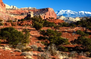
I used to think of Capitol Reef as my special place that hardly anyone else knew about. That’s no longer true, but it is much less crowded than the other parks on this route. The park encompasses the Waterpocket Fold – a 100-mile-long crease in the land offering colorful formations and great hiking.
It’s like a geology lesson, with layers of different colored and textured rock piled atop one another on the colorful cliffs alongside SR 24 and the seven-mile-long scenic drive. The Fremont River and SR 24 cross the fold and emerge into interesting badlands country on the east side.
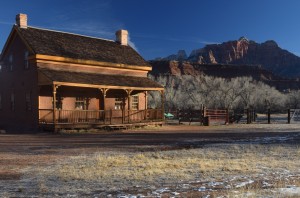
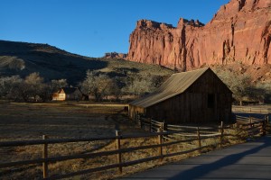
Mormon pioneers settled here. You can tour the former town of Fruita, where orchards still prosper. The highlight of Fruita is a restored farmhouse. Be sure to take the 8-mile scenic drive, which allows access to Grand Wash and Capitol Gorge – two canyons offering hiking trails and more spectacular scenery. The park’s entry fee is $10 per vehicle.
On the east side of the park is the junction with the Notom-Bullfrog Road, which is mostly unpaved. This is one of my favorite drives, but it’s not for everyone., It can be rough and sandy, but I managed it back in the day in a Hyundai Scoupe — a car hardly anyone bought, but which some of you will remember. You’ll find details on the park’s website or at the visitor center. Web site: www.nps.gov/care/index
Capitol Reef National Park to Moab – 150 miles
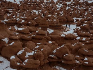
From Capitol Reef, SR 24 will take you to Hanksville, where there’s an important junction. If you stay on SR 24, you’ll hit I-70 after 43 miles. Be sure to take the short side trip to Goblin Valley State Park for more fanciful stone formations. Take -70 east for 33 miles to US 191, then head south 26 miles to Moab.
For a longer route offering better scenery, turn right at Hanksville onto SR 95. It takes you 125 miles to Blanding. Along the way, you cross the Colorado River at the north end of gorgeous Lake Powell, then pass the turnoff to Natural Bridges National Monument, which is well worth a visit. At Blanding, turn left onto US 191 and go 82 miles to Moab. This route adds another 100 miles to the drive.
Moab used to be a remote Mormon town, but it’s been transformed into a major visitor destination. It’s at the heart of a virtual cafeteria of recreational possibilities. Moab is the world’s mountain biking capital, as well as the jumping-off point for whitewater raft trips, backcountry 4×4 trips, scenic flights and scenic drives. It’s also the gateway to Arches and Canyonlands National Parks. Moab is always busy; be sure to make lodging reservations well in advance. You could easily spend a week here.
Useful web sites:
Goblin Valley — stateparks.utah.gov/parks/goblin-valley/
Natural Bridges NM — www.nps.gov/nabr/index
Moab — www.discovermoab.com
That concludes Part One of the southwest road trip post. Part Two will appear January 28 and cover the route from Moab to Las Vegas, including Arches and Canyonlands National Parks.