

Welcome to Part Two of our Great Southwest road trip. If you live in California, Arizona or Nevada, you should start with Part One, posted a week before this one.
This is a complete itinerary for a road trip vacation. The trip duration depends on how long you stay at the destinations you’ll be visiting. And each destination offers you lots of reasons to tarry. None offers more than the town of Moab, Utah, which is the recreational hub of the Southwest. That’s our starting point for Part Two of the Great Southwest road trip. Details about Moab are in Part One of the itinerary.
Arches National Park
Arches and Canyonlands National Parks offer great sightseeing, hiking and camping. And they’re both at Moab’s doorstep. We’ll start with Arches.
Arches is my favorite national park. Or it was. The love affair began during my first visit, back in the late ‘70s when I was an AAA travel writer specializing in the Southwest. The park road was only partially paved, and few people knew about this geologic gem of a park. That’s changed. Arches now gets 1.2 million visitors a year, and that number is growing at an annual rate of 10 to 15 percent. Crowding has become a challenge.
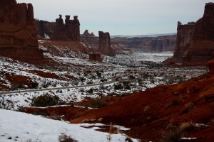
My last two visits were in late December 2013 and late October 2015. During both visits it was hard to find parking in the most popular spots, even though it was ostensibly the off-season. It’s easy to see why. Just about everyone I talked to was in awe of the amazing landscape here, which is full of monumental natural sculptures of vivid reddish-brown sandstone. The park has hundreds of natural stone arches, along with pinnacles, fins and more other-worldly formations – with a backdrop of the 12,000-foot peaks of the La Sal Mountains. In addition to a spectacular scenic drive, there are excellent hiking trails. There’s a campground, but it’s full by noon every day from March to October.
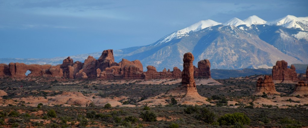
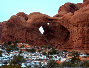
The park entrance is literally just outside Moab off US 191. The visitor center is right next to the kiosk where you pay your $25 per vehicle entrance fee. The park road climbs a couple of switchbacks, and you immediately find yourself in another world. At a minimum, you’ll want to drive the 18 miles to the end of the scenic drive, with a short side trip to the Windows Section. Spend some time walking around the Windows area, where you’ll find several arches, including the unique Double Arch. If you’re up to a 3-mile round-trip hike, take the trail to Delicate Arch – the formation appearing on many Utah license plates. Lastly, take the Devils Garden Trail at the end of the scenic drive. It leads to Landscape Arch, at 291 feet the world’s longest natural arch. The scenic drive is fine for bicycling; the only steep climb is at the beginning.
For more information, including tips on avoiding crowds, check out the park’s website: www.nps.gov/arch
Canyonlands National Park
Canyonlands has four sections, only two of which can be reached in Old Betsy. Entrances are at the north and south ends of the park. Paved roads lead to both entrances from US 191, but they don’t connect; you’ll have to retrace your steps. Both districts are spectacular, but they’re very different. I recommend you visit both, if time permits.
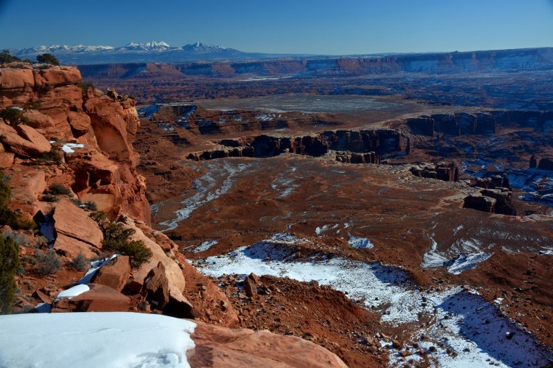
Most people will prefer the Island in the Sky section, which is closest to Moab. There, you’ll find yourself on an ever-narrowing mesa top overlooking a wilderness of sculpted stone 2,000 feet below. To get there, drive north from Moab on US 191 and turn left after 9 miles onto SR 313. You’ll arrive at a junction after about 18 miles. SR 313 turns toward Dead Horse Point State Park. The right-hand fork goes to Canyonlands, which attracts substantially fewer visitors than Arches.
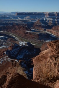
By all means, take the turnoff to Dead Horse Point. The view of a sharp bend in the Colorado River 2,000 feet below is well worth the $10 entry fee. It’s hands-down one of the most superlative viewpoints you’ll ever experience. For more information, go to stateparks.utah.gov/parks/dead-horse. You’ll find a visitor center, seasonal cafe and a campground.
Continuing south, the road to Canyonlands soon enters the park and arrives at the visitor center, where you pay your $25 per vehicle entry fee. A few miles farther, the road ends at aptly named Grandview Point — pictured at the top of this post. The Island in the Sky district isn’t rich in hiking trails, but it’s got some great 4×4 roads. Check at the visitor center or the park’s website for details. The small Willow Flat Campground is on the side road to Upheaval Dome.
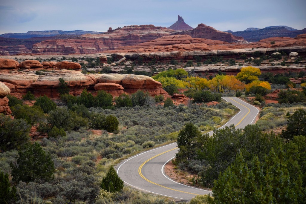
The second section you can drive to is the Needles District, which is about two hours from Moab. Take US 191 south for 40 miles, then head west 35 miles on SR 211. The Needles Section doesn’t reveal itself fully to people who stay on the paved road. There are several excellent hiking trails and 4×4 roads leading to spectacular geologic formations. This is where many of the 4×4 trips offered by Moab’s tour companies go. It’s also where you’ll find the infamous Elephant Hill 4×4 trail. To see it, go to YouTube and enter Elephant Hill in the search box. Not far from the visitor center is the Squaw Flat Campground, which fills up only in summer. You’ll find the park’s website at www.nps.gov/cany
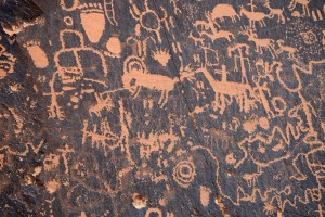
Be sure to stop along the way at Newspaper Rock State Park – probably the most extensive Indian rock art site accessible by car. Experts aren’t sure if the drawings represent communication or doodling. Most are between 1,000 and 2,000 years old. The site is a short stroll from the parking lot. There’s a restroom but no other facilities. It’s free to visit.
Moab to Four Corners – 153 miles
Drive 54 miles south of Moab on US 191 (or 12 miles past the turnoff to Canyonlands’ Needles Section) to Monticello, then turn east on US 491. (This used to be US 666, but the federal highway gods changed the number to avoid what some might perceive as a Satanic reference.) After 16 miles you’ll enter Colorado and pass through the largest pinto bean growing area in the country. Continue to Cortez.
For an interesting optional side trip, take US 160 11 miles to the entrance road of Mesa Verde National Park. It’s about 21 miles on the narrow, winding park road to get to the main visitor attractions. Mesa Verde is famous for its ancient cliff dwellings, some of which you can tour. There’s a lodge in the park, but you’ll get better value for accommodations in Cortez. The entrance fee is $15 from Memorial Day to Labor Day — $10 before and after those dates. The cliff dwelling tours cost an additional $4 per person; get tickets at the visitor center. Website: www.nps.gov/meve
Back on the main tour route, US 160 southwest from Cortez for 38 miles to the only place where four states come together. It’s kind of silly, but everyone stops here to get their photo taken on the stone slab with a marker showing the exact point. The Utah, New Mexico and Arizona quadrants are Navajo territory, and the Navajo take advantage by charging admission (usually $5) and setting up displays of jewelry and other native crafts. The Colorado quadrant is Ute land. The Utes don’t have a presence at Four Corners; they’d prefer you stop at their big casino 10 miles south of Cortez.
Four Corners to Monument Valley – 100 miles
If you want to give a pass to Mesa Verde and the Four Corners, you can head directly from Moab to Monument Valley via US 191 and 163; driving distance is about 145 miles. Likewise, if you’re coming west on US 160 from the Four Corners, you can skip Monument Valley and head directly to Flagstaff or the Grand Canyon. Monument Valley is about 24 miles north of US 160 on US 163.
Everyone should see Monument Valley. If you haven’t, take the side trip. It’s a spectacular landscape of dramatic buttes that’s been featured in umpteen movies and TV shows. Monument Valley is a Navajo tribal park. You’ll pay a $20 entrance fee, which lets you take a 17-mile scenic drive on an unpaved, somewhat sandy road that winds among the formations. Guided tours will take you to places you can’t go on the scenic drive. The park’s website has a list of tour operators. Go to www.navajonationparks.org/htm/monumentvalley
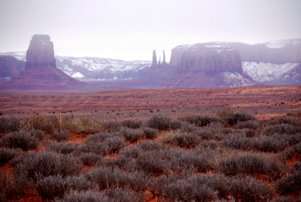
You’ll find accommodations at the venerable Gouldings Lodge (expensive), in the town of Kayenta (junction of US 160 and US 163, and in Mexican Hat, Utah. If you’d like to gain some perspective on the Navajo, read one of the mystery books by Tony Hillerman.
Monument Valley to Flagstaff – 172 miles
From Monument Valley, drive south to Kayenta on US 163, then head west on US 160. After another 82 miles, turn left onto US 89. Drive 15 miles south to Cameron, which is where you’ll turn (SR 64) if you want to visit the Grand Canyon. I won’t provide details on Grand Canyon National Park, other than to say it’s overrun with hordes of people much of the year. Still, it’s truly spectacular.
Skipping the Grand Canyon? Flagstaff is an ideal place for an overnight stay. It’s a major crossroads of the Southwest . Just north of Flagstaff, a loop road takes you to a pair of interesting national monuments – Wupatki (Indian ruins) and Sunset Crater (a volcano). If you have time, be sure to visit the outstanding Museum of Northern Arizona.
Flagstaff to Kingman (144 miles)
You’re on the home stretch now if you began your Great Southwest Road Trip in Las Vegas. If you’re headed to Phoenix, take I-17 south from Flagstaff. If you’re going to California or Las Vegas, take I-40 west. If you took the side trip to the Grand Canyon, take SR 64 south to Williams, where you pick up I-40. You’ll find accommodations (and not much else) in Kingman.
Kingman to Las Vegas – 95 miles
For Las Vegas, take US 93 from Kingman all the way. You’ll pass right by massive Hoover Dam (tours available).
Kingman to Los Angeles or San Diego (322 miles to LA, 374 miles to SD)
I-40 takes you 48 miles from Kingman to the California border. Tip: Buy gas in Arizona! Needles, on the California side of the Colorado River, is notorious for gouging motorists on gasoline. At Barstow, I-15 will take you directly to San Diego. For Los Angeles or Orange County, I’ll trust you know the way.
That concludes our Great Southwest road trip. Hope you enjoyed it! Next step: Take the trip!