

This week Road trips with Tom is primed for adventure, as we take on Arizona’s legendary Apache Trail – one of the best desert drives you’ll find anywhere.
It’s a 180-mile loop out of Phoenix. You can easily make a nice day trip out of it, although you may want to add time for camping, fishing and boating. That’s right – watersports; the drive follows the Salt River and a series of sparkling lakes amid some of the most beautiful Sonoran Desert scenery in the Southwest. Like the song says, “Ain’t nothing like it nowhere.”
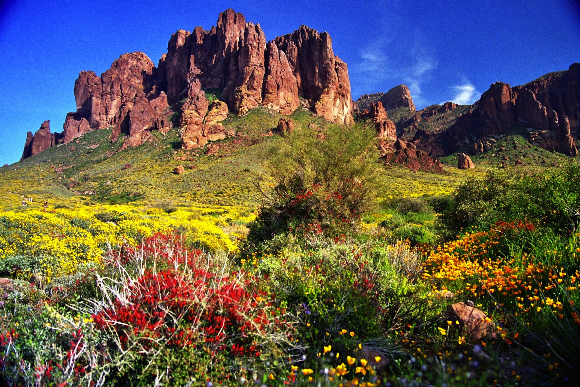
If you’re a regular reader of this blog, you’ll have noticed that I love the open spaces of the West – rugged, naked landscapes, endless vistas, deep blue skies, minimal humidity. That pretty much describes Arizona, which offers the bonus of the Sonoran desert and forests of majestic saguaro cacti. It also describes this road trip.
I love this drive, and so will you!
Dirt road keeps the riffraff out
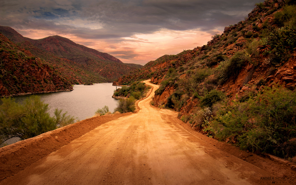
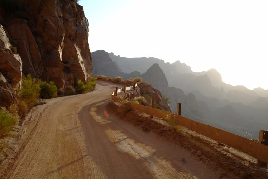
I’ll guide you on this trip, but be prepared: Old Betsy is going to get dusty, because the heart and soul of the Apache Trail is steep, narrow and unpaved. But don’t let that scare you off. It’s just enough to keep the riffraff out, but you’ll experience no more than a few bumps and a bit of dust. Drive carefully, and you’ll be fine. The entire route is on Google Street View, so you can check it out before leaving home. You’ll notice the roadway is wide enough for passing, and there are overlooks and turnouts along the way. You should be able to safely drive at 35-40 mph most of the way.
A couple of cautions: Despite the relatively benign nature of this road, leave your RV at home. Second, if you want to tow a boat trailer to Apache Lake, follow the described route. For Canyon Lake, on the other hand, drive directly from Apache Junction to avoid the unpaved section.
Phoenix to Globe
I’m writing this as if you’re making a one-day loop out of it. You’ll want a sunny or mostly sunny day. (Those aren’t hard to come by in Phoenix.) Even though you’ll climb above 2.000 feet, don’t expect a break in the summertime heat. Stick to winter and spring. The trail never gets crowded, but nice weekends bring crowds to the campgrounds and other recreation areas.
Your goal should be to begin the Apache Trail in the early afternoon. That gives you good backlight for viewing the road surface and for photography without blinding you. There are a few enticements along the way. I’ll point them out and offer up some web links.
From the interchange of I-10 and US 60, take US 60 (the Superstition Freeway) east, then stay on 60 after the freeway ends. Continue 60 miles or so to the old copper mining town of Globe. In Superior is the Boyce Thompson Southwest Arboretum – the state’s oldest and largest botanical garden. For more information, go to https://arboretum.ag.arizona.edu/location.html.
At Globe, you may want to have an early lunch or buy picnic provisions.

Globe to Roosevelt Dam
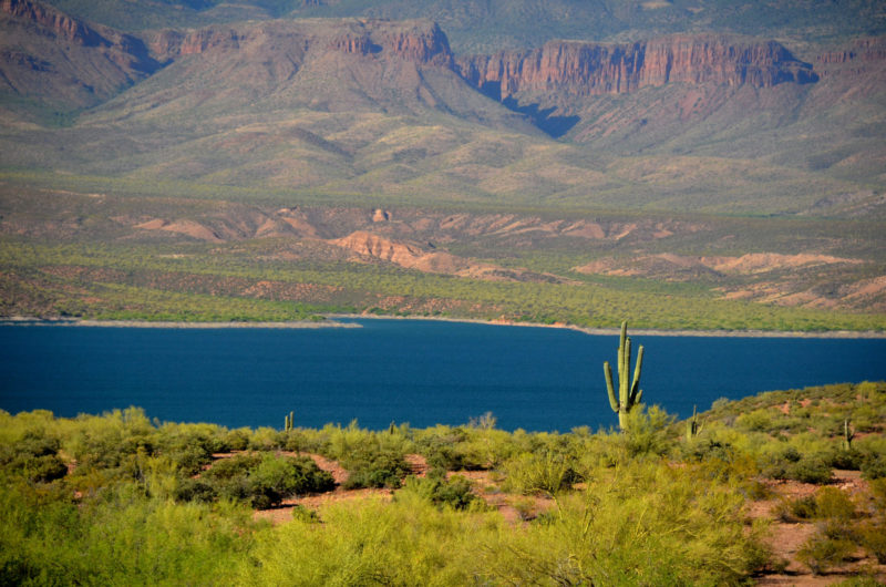
At Globe, turn north on SR 188 and drive 30 miles to Roosevelt Dam. Before you get there, you’ll come alongside Roosevelt Lake – largest of the Salt River lakes that provide Phoenix’s water supply. The Tonto National Forest operates a visitor center that’s open daily and offers restrooms, exhibits, expansive views and picnic tables. Go to https://www.fs.usda.gov/recarea/tonto/recarea/?recid=35753.
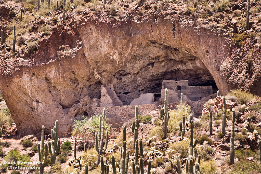
Another worthwhile stop is Tonto National Monument, where you’ll find a pair of ancient cliff dwellings in a forest of saguaros. The half-mile uphill hike is a good way to stretch your legs before heading down the Apache Trail. For details on the monument, go to https://www.nps.gov/tont/index.htm
Roosevelt Dam to Tortilla Flat
Okay, let’s take the plunge onto the Apache Trail. Turn left onto SR 88. Reset your trip odometer to zero here; my mileages begin here.
On your right is Roosevelt Dam, nearly 100 years old and still the world’s highest masonry Dam. There’s an interpretive overlook at the junction.
Just past the dam, a sign announces you’re on a U.S. Forest Service Byway, and the pavement ends. Most of the Apache Trail is part of the Tonto National Forest. There are several campgrounds along the trail. For details, go to https://www.forestcamping.com/dow/southwst/tontinfo.htm
Here are the landmarks you’ll encounter in this section:
5.5 Turnoff to Burnt Corral Campground. With sites right on the water, this is one of the area’s most popular campgrounds. It’s usually full on weekends.
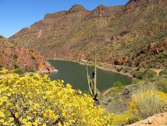
12.6 Apache Lake Viewpoint and turnoff to Apache Lake Marina. Offers lodging, food and boating. Go to http://apachelake.com/
17.0 One-lane bridge crosses Fish Creek. The road begins a steep three-mile climb with a 1,000-foot dropoff on the right. This is where you’d earn your “I drove the Apache Trail” T-shirt if there was such a thing. Just drive slowly and carefully, and don’t look down. There’s a great viewpoint at the top.
20.1 Fish Creek Canyon viewpoint.
22.0 Pavement resumes.
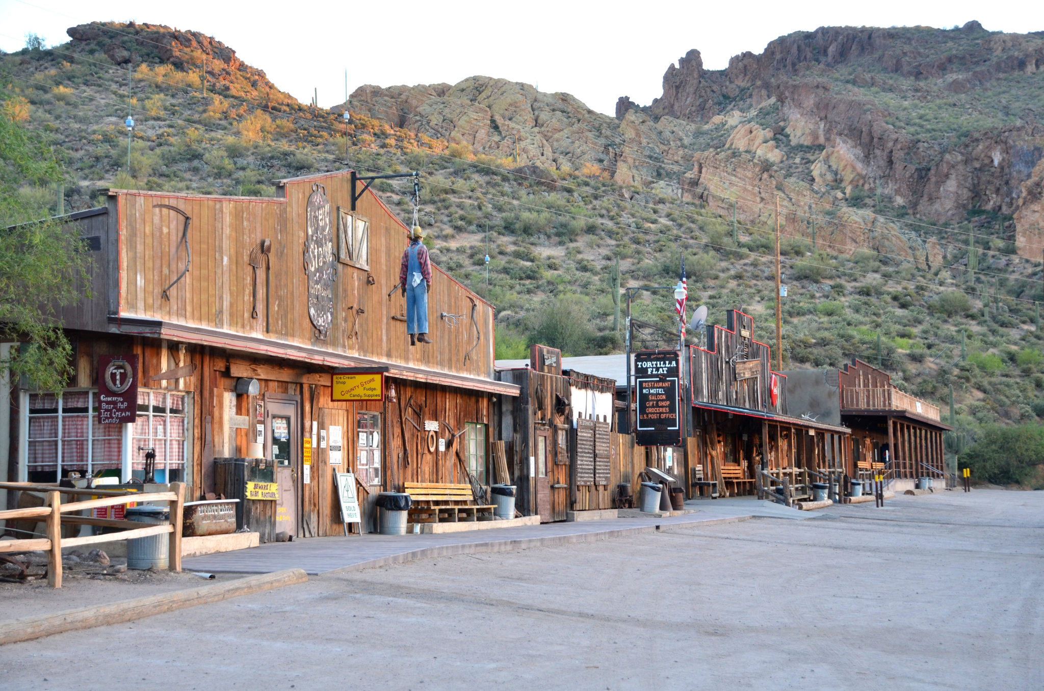
27.7 Tortilla Flat (population 6). An Old West outpost offering a restaurant, store and gift shop. Go to http://www.tortillaflataz.com/ A popular campground is across the road.
Tortilla Flat to Apache Junction
29.8 Canyon Lake Marina, offering everything including a tour boat. Go to http://www.canyonlakemarina.com/
32.5 Canyon Lake Viewpoint.
From here to Apache Junction, the Apache Trail leaves the national forest and returns to civilization. There are a couple of attractions that might interest you. One is Lost Dutchman State Park, a very popular (and often crowded) spot offering camping and a network of hiking and equestrian trails. Campsites can be reserved in advance. Go to https://azstateparks.com/lost-dutchman/
The other is a genuine old mining town that’s been tarted up for people like you and me. Go to http://goldfieldghosttown.com/
SR 88 will lead you back to US 60. Turn right to return to Phoenix.
Wow, that was fun. Let’s do it again some time. Meanwhile, we’ll be back April 16 for a visit to the Black Hills tourist town of Deadwood, S.D.