

This week Road Trips with Tom takes you to the Pacific Northwest, specifically to the spectacular Columbia River Gorge. It has all the ingredients for a great trip – the lushest, greenest rainforest imaginable, the West’s greatest river, a wealth of wonderful waterfalls, and hikes ranging from easy walks to challenging treks. A secondary attraction is historic . . . the epic journey of Lewis and Clark.
That’s not all. The gorge is easily accessible from a major city and has an interstate highway that will whisk you there in minutes. This is one of the West’s best road trip destinations and one of the half dozen or so most scenic drives in North America. It can easily be combined with other great destinations, such as the Oregon Coast, Mt. Rainier National Park, or Seattle.
Of course, the combination of the Columbia Gorge’s amazing scenery and easy access brings big crowds – over two million visitors per year. Most come in summer. If you’d like to join them, that’s great, but you’ll need a strategy for mob avoidance. At the bottom of this post I’ve provided a series of tips for making your visit rewarding and hassle-free. After all, the last thing you need on vacation is big-time traffic and Disneyland-like crowds in a scenic place, which is the vibe here on summer weekends.
You don’t have to come in summer for the best weather. Heck, it rains more often than not here, whatever the season. For example, two days before this was written, I had lunch in The Dallas, Oregon, where it was 80 degrees and sunny. An hour later and 40 miles to the west, it was chilly and rainy. Mid-April to Memorial Day is also a great time to visit. So is fall, when the undergrowth turns yellow, orange and red. Of course, the waterfalls’ flow dwindles then, too. In other words, whatever time of year you pick to visit the gorge, chances are good you’ll have gray skies with light drizzle.
The Columbia Gorge is shared by Oregon and Washington. Most of the good stuff is on the Oregon side, and that’s where you’ll be spending your time. This isn’t a long drive – 60 miles or so.
Allow at least half a day to stop at the places described below. Active adults who like to hike will find great trails to even more spectacular waterfalls; allow at least a full day for that. Children may get antsy after a few hours. The good news is you can hop onto I-84 and be back in Portland in less than an hour.
The Columbia Gorge mile by mile
With this post, the blog introduces a new format we’ll use from time to time. It’s a mile-by-mile guide to one scenic highway. In this case, it’s the Columbia River Scenic Byway, also known as Historic US 30.
As you poke along this scenic backroad, it’s hard to envision this as the main route of transcontinental US 30, but that’s what it was when opened to traffic in 1916. Now, it shares the gorge with Interstate 84 and the tracks of the Union Pacific. For most of the way, however, the freeway is out of sight and out of mind.

The road is narrow and winding, with occasional turnouts. Do NOT bring an oversize RV or trailer here! Your average speed will be 25-30 mph. You’ll find restrooms, parking areas and picnic facilities at some of the most popular stops.
The description I’m providing is a route I drove on June 24. Mileages are based on odometer readings in a Toyota Corolla rental car.
Let’s begin. I recommend you stay in Portland and drive the route from west to east. To avoid city traffic, you’ll want a hotel on Portland’s east side. The hotels near Portland Airport are a good choice. Start by taking I-84 east. The official scenic route begins at Exit 17, but let’s cut to the chase, shall we? Take Exit 22 for Corbett. Drive 1.4 miles up a 10 percent grade to the scenic highway, then turn left. Reset your trip odometer to zero at this junction.
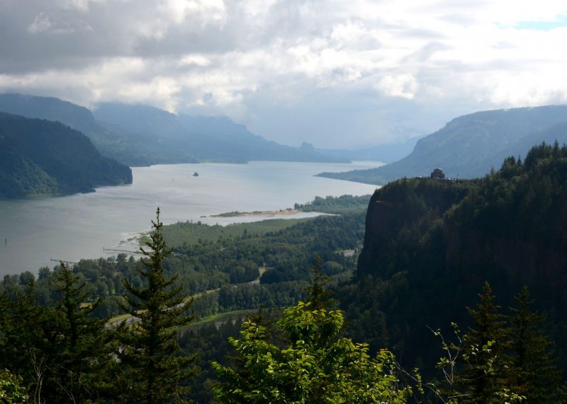
Mile 1.4 on your left. Turn into Portland Women’s Forum State Park, and find a parking space close to the farthest end. This is the iconic view of the Columbia Gorge, with the Vista House sitting atop Crown Point in the foreground. It’s shown on the photo at the top of this post. Comparing the number of people I saw here compared to other locations farther east, I would guess that not everyone knows about this place. Don’t miss it!
Mile 2.1 on your right is the turnoff for Larch Mountain. If it’s a rare clear, sunny day (never experienced in my half dozen prior visits), the top of Larch Mountain gives you a great view of the Cascade volcanoes from Mt. Rainier in the north to Mt. Jefferson in the south. It’s a 16-mile drive on a narrow paved road.
Mile 2.8 is the Vista House, built in 1918 as a stopping point for travelers. It sits atop Crown Point and provides a sweeping view of the gorge. It was refurbished and reopened in 2006. Inside are marble restrooms, displays and a gift shop. Caution: It’s always windy here. Over a million people per year visit Vista House.
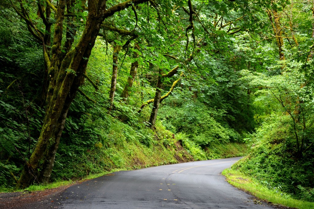
Beyond Vista House is some of the lushest forest you can imagine. The road is especially narrow and twisty here, and should be driven at a slow mosey. In addition to trees, you’ll see dense growth of ferns and mosses. Even some of the original stone bridge abutments are covered with moss!
Mile 5.2, on the right, is the parking area for 249-foot Latourell Falls, part of Guy W. Talbot State Park. You’ll see two trails. The one on the left climbs to a viewpoint, while the trail on your right goes down to creek level then climbs to the base of the falls.
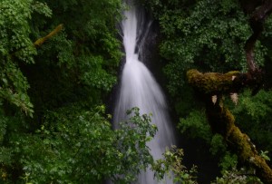
Mile 6.4, on the right, is Sheppard’s Dell. Here, you walk down a series of steps to get views of a two-tiered waterfall. Look back up toward the road to view the interesting, moss-covered stone bridge. Surprisingly, there was no one here on the 24th!
Mile 7.3, on the left. Parking lot entrance for Bridal Veil Fall, where a stream falls 100 feet then another 160 feet right under the road. There’s a short walk from the parking lot to the viewpoint. Very crowded at 11 a.m. on 6/24.
Mile 8.0, access to I-84 west, on the left.
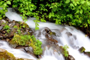
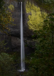
Mile 10.5: After running right alongside the freeway and railroad for a couple of miles, the highway brings you to Wahkeena Falls, on the right. This is a tiered fall totaling 242 feet. The outlet stream rushing through lush vegetation makes for nifty photos. This stop gets crowded in summer.
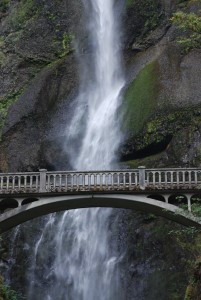
Mile 11.0 is Multnomah Falls. At 620 feet, this is Oregon’s highest waterfall and one of the highest in the United States. Here, you’ll find a café, gift shop, hiking trails and approximately two zillion people. Parking can be very difficult. About a third of the way up the falls, a stone bridge crosses the stream from left to right. You might disagree, but I think the bridge detracts from the view. Coming from Portland, you can get directly here by taking I-84 Exit 31.
Mile 13.2, Oneonta Gorge on the right. There’s a waterfall some distance upstream, but you have to wade in the creek to get there. I tried once, and fell in the stream. What makes Oneonta special is its incredibly lush vegetation. You’ll find parking on the right near an old tunnel.
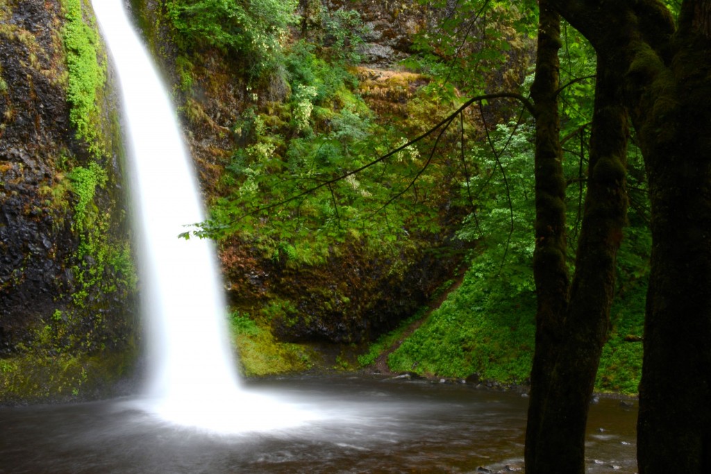
Mile 13.7, on the right, is Horsetail Fall, which drops 176 feet into a pool that’s literally right next to the road. This is my favorite Columbia Gorge waterfall.
Mile 14.1, on the right, is Ainsworth State Park’s picnic area, which has tables situated next to a gorgeous rainforest. This is a great place to decompress after fighting for parking spaces and dodging other people’s obnoxious children at prior viewpoints. Ainsworth has a campround just beyond the picnic area. You’ll need to reserve a site here; go to www.oregonstateparks.org/index.cfm?do=parkPage.dsp_parkPage&parkId=105. The reservation system also includes a couple of state parks off I-84 by the river.
Mile 17.3. Here, this segment of the scenic highway ends, and you can enter I-84 eastbound. If you’re thinking about returning to Portland, don’t . . . there’s more good stuff ahead!
Climatic change
In this segment of I-84, you can exit to tour Bonneville Dam (Exit 40), visit the community of Cascade Locks, or take the Bridge of the Gods (Exit 44) to the Washington side. Next, continue to Hood River, a fruit packing town that tries very hard to be hip. It’s a good place to stop for lunch; use Yelp. This section of the Columbia Gorge is one of the country’s meccas for windsurfing. Hood River’s riverfront and nearby Viento State Park are good places to watch the windsurfers. You can even take lessons.
If it’s a clear day (rare), take this side trip: Turn south on SR 35 (Exit 64), drive south a short distance, then go left onto East Side Road. Not far down the road is the turn to Panorama Point, which overlooks the beautiful fruit orchards of the Hood River Valley, with Mt. Hood in the background. SIDEBAR: I think Mt. Hood is afraid of me. Every time I’m in the area, it hides behind clouds! Maybe you’ll have better luck.
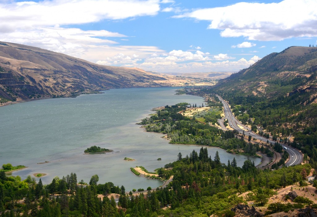
Just beyond the Hood River turnoff, the land undergoes a dramatic change. At this point, most of the moisture has been wrung from the clouds. In a short distance, you experience a transition from lush forest to oak and ponderosa savanna to desert scrub. If you’ve been paying attention, you’ve noticed the transition occurs sooner on the south-facing Washington side, which gets more sun.
Take the Mosier Exit (#69) for the second section of the Old Columbia River Highway. It winds and climbs 6 miles to a spectacular viewpoint at Rowena Crest, which looks upstream to the much drier environment. This area is also known for amazing wildflower displays in April. You’ll soon enter The Dalles. As you do, you’ll notice the turn to the Columbia Gorge Interpretive Center, a museum focusing on history and geology.
Logistics
The scenic highway ends just beyond the city of The Dalles. From here, you have several choices:
. Take I-84 east to Pendleton and Idaho
. Take I-84 west back to Portland
. Cross the river on US 197 and return on the Washington side (not as scenic)
. Return to Hood River and loop around Mt. Hood back to Portland via SR 35 and US 26
None of the attractions, waterfalls and viewpoints have admission fees. Here are some websites with handy information on the Columbia Gorge:
www.traveloregon.com/trip-ideas/scenic-byways/the-historic-columbia-river-highway/
http://www.hood-gorge.com/?utm_source=madden&utm_medium=googlecpc&utm_campaign=hood-gorge
Crowd management
The Columbia Gorge gets super-crowded between Memorial Day and Labor Day. If you must come during that time, here are two recommendations:
First, start early. Be at the Corbett exit no later than 8 a.m. You’ll still hit crowds, but you should be able to find a parking space at most locations (except perhaps Multnomah Falls).
Second, if you absolutely must visit Multnomah Falls, go straight there (Exit 31), and get there by 9.
Third, under no circumstances should you come on a weekend, when daytrippers from Portland flock to the gorge.
Of course, the very best idea is to visit before Memorial Day or after Labor Day