

This post continues our list of North America’s most scenic highways. In this issue you’ll find Scenic Highways 21 through 25. That completes our five-part list. Each instalment will be archived so you can come back to it whenever you want. Please use the comments button to share your thoughts on the highways we’ve included and perhaps those we’ve omitted.
I may add more later and make this the 30 or 40 most scenic, because I had to omit some great roads to get to just 25. Besides, this is fun.
Highlights in this post: The highest mountain in the Lower 48, giant saguaro cacti on the shore of beautiful lakes, the Ben & Jerry’s ice cream factory — and more! We’ll start with a highway familiar to many Southern Californians, who use it as a high-speed route to fishing lakes, backpacking routes and ski slopes.
21. US 395, Lone Pine to Bridgeport, California
Distance: 150 miles. Driving time 4 hours. This rarely appears on lists of the most scenic highways, but it’s always been one of my favorite drives. California now calls this route the Eastern Sierra Scenic Byway. I always look forward to a chance to drive it. It’s a great opportunity to view and appreciate the awesome Sierra Nevada – a range so steep and rugged that no road crosses it for over 100 miles. The Sierra is an almost vertical wall of granite rising 10,000 feet above Highway 395.
You can make a model of the Sierra with a simple brick. Hold it so it’s perpendicular to your body, then tilt it from right to left. You now have a gentle slope on the left and a steep slope on your right. That’s the model of the Sierra Nevada my geology professor used to demonstrate the lay of the land here. US 395 runs right along the base of the steep side. That’s not all. Between Big Pine and Bishop, the White Mountains on the east also rise to over 14,000 feet and parallel 395. That leaves you, the road tripper, in the 4,000-foot Owens Valley with 14,000-foot peaks on both sides. I usually have a hard time taking my eyes off those awesome mountains.

A good introduction to the area is the Eastern Sierra Interagency Visitor Center, located on Highway 395 just south of Lone Pine. Rangers are on hand to answer questions and issue wilderness permits. From Lone Pine you look directly west at Mt. Whitney – highest peak in the lower 48 (although most people can’t recognize which of the high summits is Whitney). The visitor center has a display that will show you. Want a closer look? Turn west from downtown Lone Pine onto Whitney Portal Road.
Driving north from Lone Pine, you’ll recognize the view with the boulder-strewn Alabama Hills in the foreground from the dozens of movies shot here. The only thing missing is John Wayne or maybe Randolph Scott. Also filmed near here (on Whitney Portal Road west of Lone Pine) was the classic road trip movie The Long, Long Trailer starring Lucille Ball and Desi Arnaz.
US 395 is all about the views – not the highway itself. It’s nearly straight as a string as far as Bishop. Much of it is freeway. However, it leads to side roads that will cause motorcyclists and sports car drivers to salivate. Winter snows can close the highway temporarily, or at least put tire chain restrictions into effect. Just beyond Bishop, the highway leaves the Owens Valley and climbs to over 6,000 feet.

We Californians like to drive, and people here think nothing of going 300 miles each way from LA to the Eastern Sierra to fish or ski. Consequently, the area’s population swells considerably on weekends throughout the year. Go midweek if you can. You’ll find plenty of accommodations and other services in Lone Pine, Bishop and Mammoth Lakes. Campgrounds are everywhere; any spur road heading toward the mountains will lead to at least one. Other attractions include the site of the Manzanar World War II internment camp (now a national historic site with a museum), hundreds of fishing lakes, trails leading into the high wilderness, one of the country’s biggest and most popular ski areas (Mammoth), Mono Lake with its rare tufa formations, and Bodie (the country’s best ghost town). Also here is California’s best fall foliage; peak displays occur around October 1. At Lee Vining, the Tioga Road crosses the Sierra to Yosemite National Park. It’s closed in winter. If you stay on 395, it’ll take you to Reno and Lake Tahoe, then beyond all the way to Canada.
Lastly, here’s a great route for a three-day, two-night road trip out of LA or San Diego in October. Drive I-15 to US 395, then follow it to Mammoth Lakes. Take some of the side roads, such as Whitney Portal Road and SR 168 west from Bishop. The second day, visit Bodie in the morning, then head back to Lee Vining to view the Mono Lake Tufa formations. You should have peak fall foliage along 395. Go west from Lee Vining on SR 120, cross 9,900-foot Tioga Pass into Yosemite National Park. Spend the night there, then return home the third day. Gee, that sounds so good I may do it myself!
22. Apache Trail (SR 88), Arizona
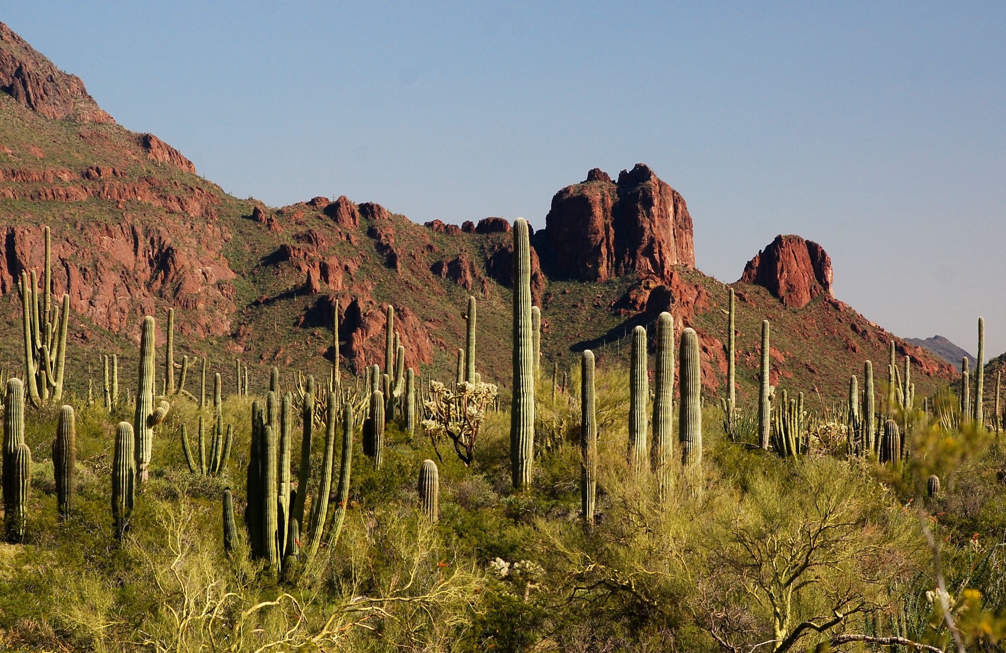
We haven’t included a desert drive in our list of most scenic highways until now. This is one of the best. Obviously, you won’t do this drive in summer unless you want to fry your brain. Instead, file this scenic drive away for later. This route shows off the Sonoran Desert at its best – rugged countryside with thick desert vegetation, including majestic saguaro cacti. It’s a 36-mile route east of Phoenix connecting Roosevelt with Apache Junction. In addition to the rugged Superstition Mountains and desert, there’s also a series of beautiful lakes that are part of Phoenix’s water supply. What keeps traffic light is that 21 of those miles are unpaved. Cars and motorcycles will handle the road just fine in good weather, but RVs should skip this one. Figure on 1½ hours’ driving time. This makes a great all-day excursion from Phoenix with a couple of recommended stops along the way (see below).
Beginning in Phoenix, take US 60 east about 85 miles east to the picturesque copper mining town of Globe. You’ll pass the notorious Superstition Mountains and man-made mountains of copper tailings along the way. A highly recommended stop is the Boyce Thompson Southwestern Arboretum in Superior. From Globe, take SR 188 north 27 miles to Roosevelt. You may want to stop to view the cliff dwellings at Tonto National Monument. Warning: The trail to the cliff dwellings is steep, and it gets very hot here. Turn left onto SR 88. Almost immediately the pavement goes away. For most of the route, the road is easy to drive and offers great views of the lakes. However, about half way along, you’ll have to negotiate the twists and steep slopes of Fish Creek Canyon. At Tortilla Flat, the pavement resumes. Then, at Apache Junction, you can rejoin the US 60 freeway to return to Phoenix.
This drive is best done on a weekday between November and May. March, when desert wildflowers bloom, is ideal. Carry water. The only services are at Tortilla Flat, which is a western-themed tourist trap and biker bar where the barstools are saddles. Tacky, but fun. Idea: Combine this day trip with a visit to baseball spring training in early March.
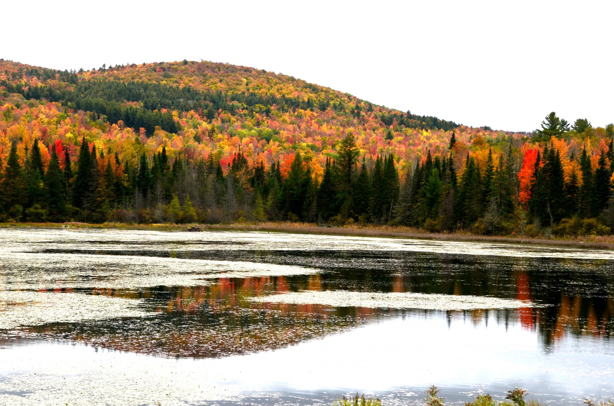
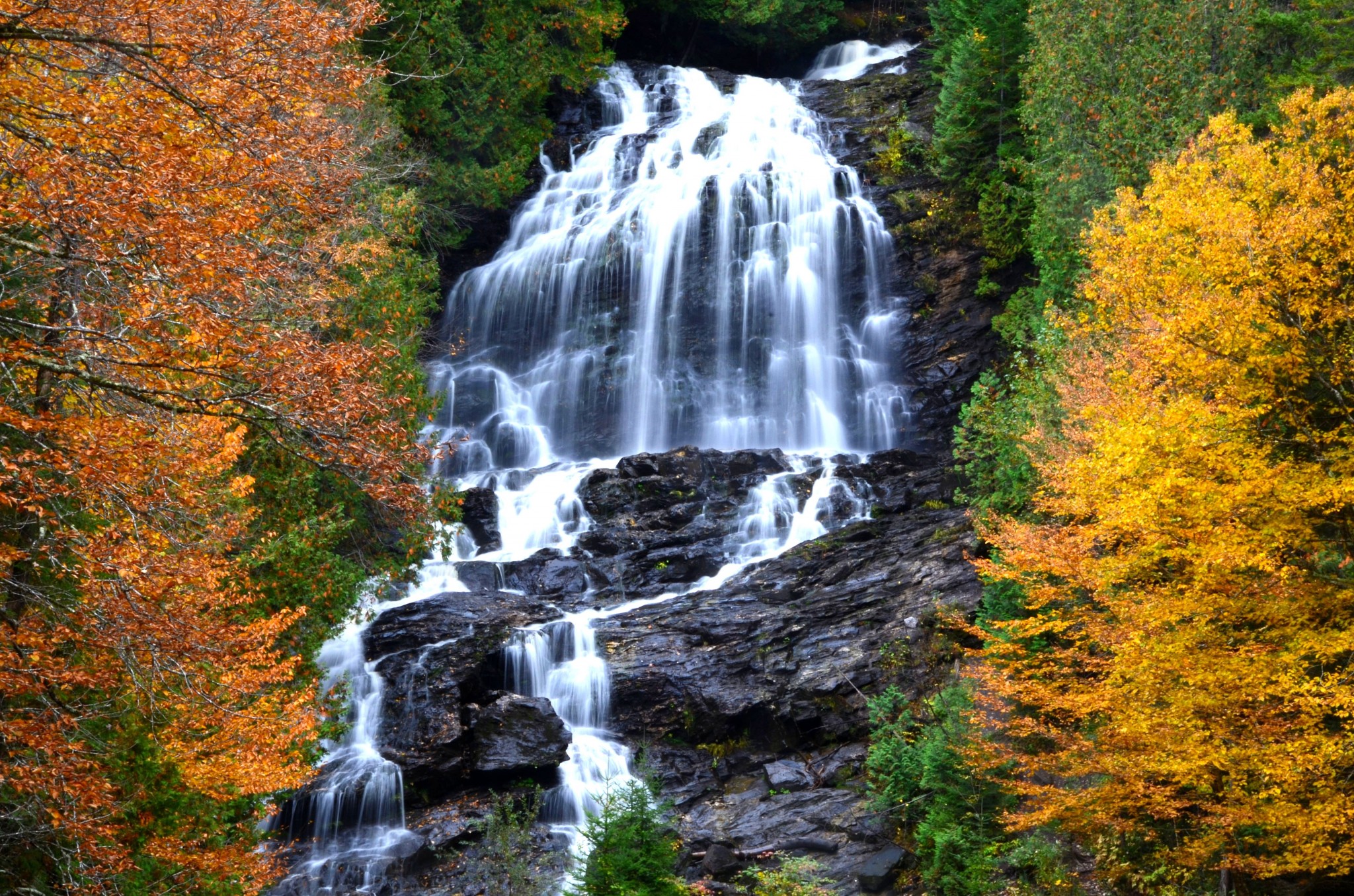
23. Vermont SR 100, Newport to Wilmington
Distance: 184 miles. Driving time: 4 to 5 hours. There are dozens of scenic roads in northern New England, but they’re mostly short. Vermont SR 100 is a consistently attractive route that runs from one end of the state to the other. It combines pleasant scenery with a generous helping of the cuteness that pretty much defines Vermont. Attractions include picture-perfect villages with traditional greens, high-steepled wooden churches, great foliage during the fall, beautiful Moss Glen Falls, the famous Vermont Country Store in Weston, plenty of upscale shopping, expensive inns, and, to top it all off, the Ben and Jerry’s ice cream factory in Waterbury. The road is fine for all types of vehicles; it’s an especially nice motorcycle route. If you’re up to a splurge, stay in the upscale village of Stowe, where you’ll find quaint inns, good restaurants and excellent shopping. Just to the west is Mt. Mansfield, highest point in Vermont. A toll road leads to the summit.
Traffic gets heavy on summer weekends, but it’s busiest during foliage season (late September to mid-October). You may not be able to find a room at that time. But distances are short in this Lilliputian state; while that makes it easy for leaf-peepers from Boston, Hartford and Providence to clog the road, it also makes it possible to stay just about anywhere in the state and commute to this route. You’ll find standard hotels in Burlington, Montpelier, St. Johnsbury, White River Junction, Bennington, Rutland and Brattleboro. Campgrounds are in the Green Mountain National Forest. My favorite stayover stop is Lebanon, N.H., which is just across the bridge from the crossroads of Vermont’s two interstates and a quick drive to just about anywhere in Vermont or New Hampshire. I already have my room reserved for mid-October.
Want to check out the fall foliage? Please read our prior post on planning a fall foliage road trip.
24. Beartooth Highway, Red Lodge to Cooke City, Montana
Distance: 68 miles; driving time: 2-3 hours. The road is seasonal. It opens around Memorial Day and is scheduled to close this year on October 13. This is a steep, twisty road, but it’s okay for all types of vehicles. This is an especially popular route for motorcyclists. If you’re flying, Billings is probably your best bet. Sadly, I don’t have any digital photos to show you. All my photos from this road were taken in the old days of slide film.
Some people consider this the country’s most scenic road. That included the late Charles Kuralt, who reported on America for CBS. It’s certainly one of them. From the attractive town of Red Lodge, the highway runs west up a long canyon, then switchbacks up to above timberline, soon crossing into Wyoming. Beartooth Pass tops out above timberline at 10,948 feet. You’ll pass lots of small lakes and enjoy views of distant peaks. The road then runs northwest back into Montana and the two mountain towns of Cooke City and Silver Gate before dipping down into Yellowstone National Park. Please be aware that you’ll have to pay a $30 entry fee ($25 for motorcycles) to enter Yellowstone. An alternative is to turn left onto Wyoming SR 296, the Chief Joseph Scenic Highway, which will take you back to Cody, Wyoming. It’s also a stunning drive. You’ll find accommodations in Red Lodge and Cooke City; campgrounds abound. In summer, you’ll need reservations. Also, Yellowstone’s campgrounds usually fill up by late morning.
25. New York SR 97, Port Jervis to Hancock
Distance: 76 miles. Driving time: 2 hours. In these posts I’ve listed some scenic highways that are a long way from anywhere. We’re going to finish our top 25 list with one that’s less than two hours from New York City.
This is the Upper Delaware Scenic and Recreational River, which is a unit of the National Park Service. The Delaware is the last major undammed river in the East. It’s great for canoeing and fishing, as well as good ol’ road-tripping. Oddly, the park service only owns 30 acres of land here; everything else is private. Highway 97 is a great motorcycle drive and a terrific fall foliage drive in early to mid-
October. Start this drive at Port Jervis, located just off I-84 where New York, Pennsylvania and New Jersey come together. That big obelisk on a hilltop to the south is High Point, the apex of New Jersey. You can drive to the top if you wish.
The starting point for SR 97 in Port Jervis is well-signed. After a section that’s carved from a cliff, the highway parallels the river as it meanders along the New York-Pennsylvania border among forested hills. The road is just fine for all vehicles, including bicycles. The towns along the way are tiny hamlets, meaning you won’t find a plethora of lodging and camping options – mostly small mom-and-pop places. Just about everything here is seasonal and shuts down between October and Memorial Day. Bridges cross the river into Pennsylvania every so often; they’ll connect you with Scranton or the Poconos. Roads leading north head into New York’s Catskills. At Hancock, SR 97 merges with the SR 17 freeway; turn east to return to New York City. Straight ahead are Binghampton and I-81. Not too far away are the Baseball Hall of Fame at Cooperstown and the beautiful Finger Lakes Region. If you’re flying, Newark or Philadelphia are good choices.
————————————————————————————————————————
Well, that’s it . . . my 25 favorite scenic highways in the U.S. and Canada. I hope I’ve given you some ideas for future road trips. Now it’s your turn. How about your own list? Did I miss one of your favorites? Your comments are welcome.