

What are the most scenic highways in North America? It depends on whom you ask. After all, scenery is a subjective thing. For example, people who love the desert think it’s beautiful. Those who don’t think those who do are crazy.
The list I’m going to share with you in this and the next few issues of Road Trips with Tom is my list – 25 of the roads I most enjoy driving. I’ve driven each of these routes at least once. For each, I’ll include just enough information so you can pinpoint the location and perhaps add to your road trip bucket list. The content is divided into five posts, each of which covers five scenic drives.
Keep in mind . . .
- Scenic value is strongly influenced by seasonality and weather conditions.
- Your taste may vary.
- For Canadian routes, I’ve used miles to indicate distance. Signs in Canada are in kilometers. If you figure 5 miles = 8 kilometers, you’ll be close.
- You’ll probably notice that many of these drives can be combined with others on a single road trip.
In this post you’ll find Scenic Highways 1 through 5. Scenic Highways #2 was inadvertently posted before this; look for the link. We’ll present the third scenic highways post in two or three weeks. Each instalment will be archived so you can come back to it whenever you want. Please use the comments button to share your thoughts on the highways we’ve included and perhaps those we’ve omitted.
- Utah State Route 12. Length: 118 miles. Driving time: At least four hours. This spectacular route goes through some of the most remote territory in the lower 48. It traverses a national monument nobody has ever heard of and connects two fabulous national parks. Highway 12 starts (or ends, depending on your point of view) at US 89, just west of Bryce Canyon National Park. It runs past a few tiny Mormon farm communities through Escalante-Grand Staircase National Monument to Boulder, then heads north to Torrey, just outside Capitol Reef National Park. For much of the way, the highway traverses a wilderness of stone you have to see to believe.
The road is fully paved and fine for RVs; it’s also an especially great motorcycle route. The stretch between Boulder and Torrey crosses Boulder Mountain and reaches 9,000 feet; it’s officially open all year but only if winter conditions permit. Spring and fall are the best times for Highway 12. Summer gets hot. Nearest major airports are Las Vegas and Salt Lake City.
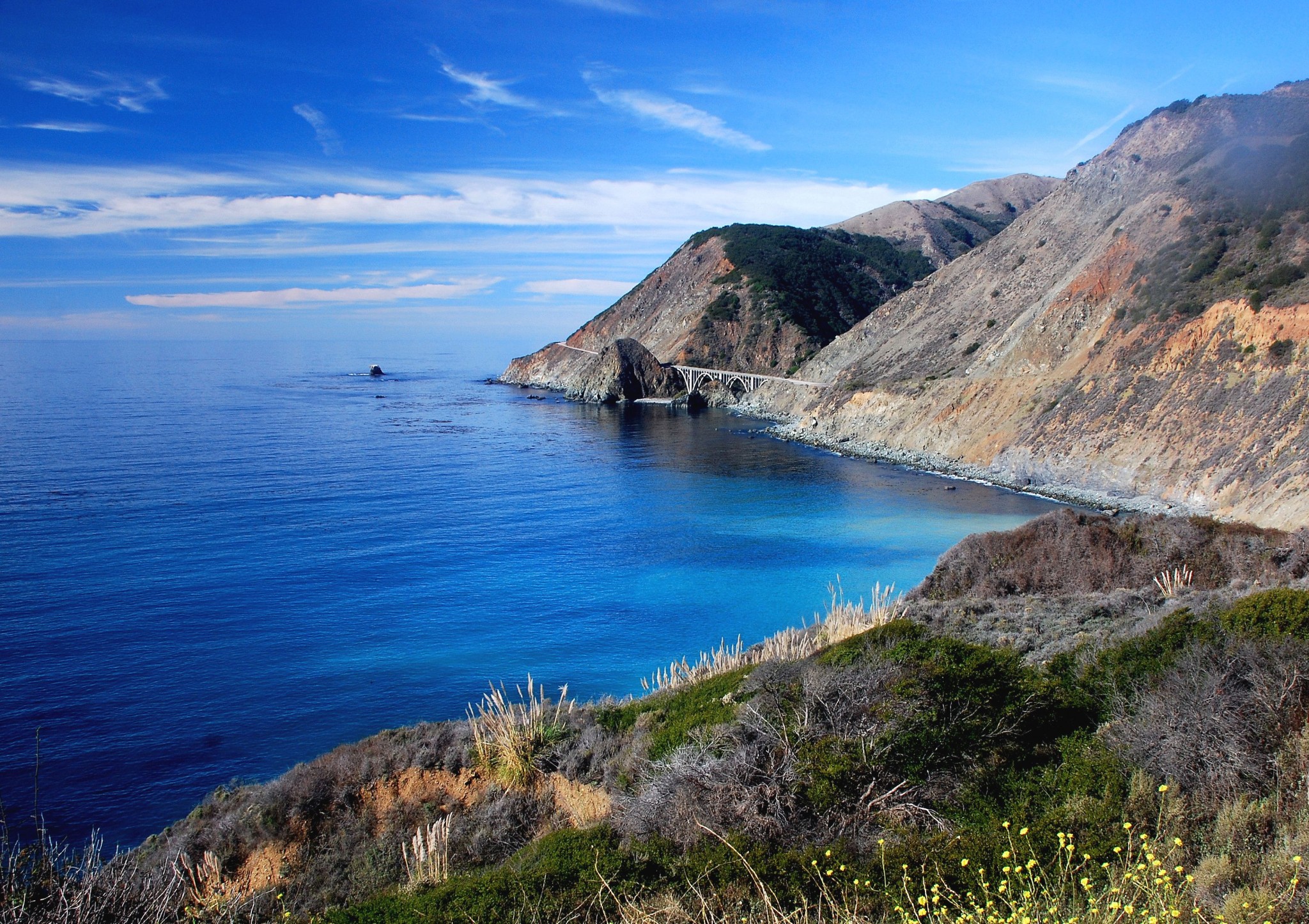
- Big Sur Highway (California SR1). Length: 134 miles. Driving time: At least four hours. Everyone has heard about this road (pictured above); it’s been called the most spectacular piece of coastline on the continent. It’s a twisty two-lane road that rises and dips past mountains that rise almost straight up from the ocean. Where the Big Sur route starts and stops is open to interpretation, but I’ll use San Luis Obispo as the arbitrary start and Monterey as the end. It starts getting seriously serpentine just past the wildly tacky Hearst Castle. The road is okay for RVs, but PLEASE make use of turnouts. You’ll be very unpopular if you chug along at 25 mph in your Winnebago. It’s also a wonderful road for motorcycles. Lastly, don’t expect to have the road to yourself; it’s tremendously popular. I suggest you make this trip on a weekday in spring, fall or winter. In summer you get a double-whammy – lots of traffic plus fog on most days. TIP: Drive Big Sur from south to north. That way the dropoff will be across the road from you. Bring your own snacks and drinks, because there are very few services along the way. You’ll find accommodations near either end, and quite a few campgrounds along the route.
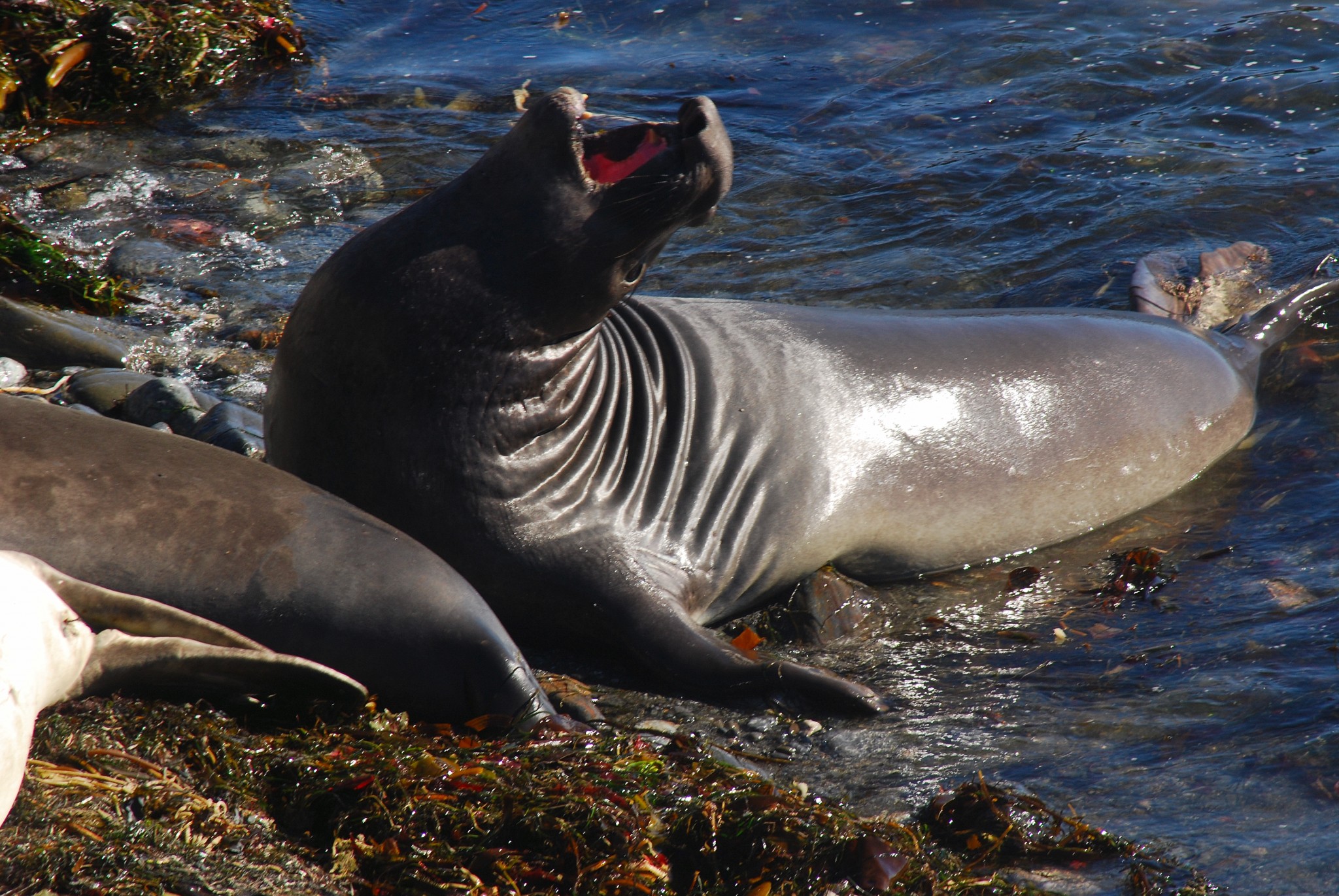
SPECIAL TIP: Five miles beyond Hearst Castle is Piedras Blancas Lighthouse. Just south of there, watch for a parking area on the ocean side of the highway. This is the best place to view rare elephant seals, especially in December and January. Unlike the more famous Ano Nuevo Beach near Half Moon Bay, you don’t need reservations and a tour ticket. Just walk to the edge of the cliff and look down. Morning is the best time.
NOTE: I prefer the northern segment of SR 1in Sonoma and Mendocino Counties. It has comparable scenery, more civilization, but a fraction of the traffic. I’ll provide details on that segment in a future issue.
- Columbia Gorge, Oregon. Length: Less than 30 miles. From Troutdale to Dodson, old US 30 parallels I-84 along the West’s biggest river, the Columbia. The old road is now officially the Columbia Gorge Scenic Byway. Along the way, you’ll find some of the lushest forest you’ll ever see, plus an amazing concentration of waterfalls. The road is great for cars, motorcycles and bicycles. I’ve never noticed a restriction on RVs, but the road is very narrow; if you’re towing another vehicle, park the RV and use your towed vehicle.
You can do this drive any time of year, but be prepared for rain. This is, after all, Oregon. I’ve made this trip at least 10 times and gotten rained on just about every time. That’s why it’s so incredibly green. Oh, and since the Columbia Gorge is right on Portland’s doorstep, avoid weekends, when it gets extremely crowded. Summer days are busy regardless of the day or the weather.
Here are directions:
- Spend the night in the Portland area. Hotels near the airport are ideal for a quick getaway.
- Leave town on eastbound I-84. You can bring a picnic lunch or find restaurants in Cascade Locks or Hood River.
- Take Exit 22 for Corbett.
- Drive up the steep hill, then turn left on the Columbia River Byway.
- In less than one mile, enter Portland Women’s Forum State Park on the left. This is the classic view of the Columbia Gorge, with the iconic Vista House perched on Crown Point in the foreground.
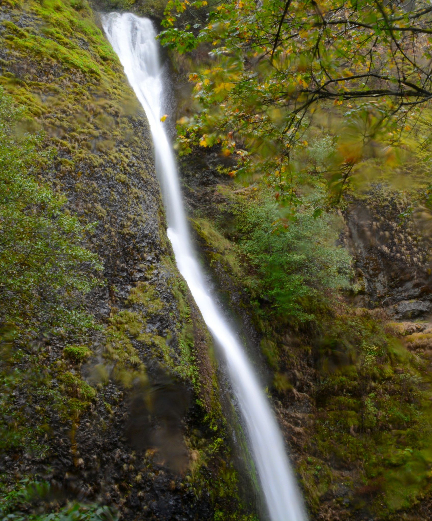
From here, continue east, enjoying the waterfalls and viewpoints along the way. Eventually, you’ll come to Multnomah Falls, at 620 feet Oregon’s highest. This is where all the people are. To continue east, don’t get on the freeway here; you’ll want to visit Horsetail Tails, a few miles farther east on the scenic highway. It’s literally right next to the road, yet it’s rarely crowded. You’ll find an onramp to I-84 east just beyond that. Ainsworth State Park, just down the road a piece, is a great picnic spot.
TIP: At Hood River, take SR 35 south a mile or two, then go left on East Side Road. That takes you to Panorama Point, which overlooks the beautiful orchards of the Hood River Valley, with Mt. Hood in the distance. You may have to trust me on this, because the mountain is rarely visible through the clouds.
- Cullasaja River Gorge, North Carolina. I’m a sucker for waterfalls. If you are, too, don’t miss this short section of US 64 in western North Carolina. You’ll find four waterfalls on this short 14-mile stretch, including one you can walk behind and one you can actually drive behind. The route runs between the towns of Franklin and Highlands. It’s a very narrow, winding road – especially good for motorcycles. But please don’t even think of taking an RV on this stretch. I recommend you start in Franklin and drive south. The first waterfall, Cullasaja Falls, is on the right. It’s clearly visible from the highway, but there’s only a tiny turnout big enough for maybe two cars. Too bad – it’s the most impressive waterfall of the lot. Next is Dry Falls. There, you’ll find a parking lot and a trail down to the falls. It’s called “dry” because you can walk behind the fall without getting wet. Also on the right is an unmarked fall that’s more like a series of rapids. And finally, you’ll pass Bridalveil Falls on the left. Last time I was there (December 2014), the road behind the falls had been opened. Highlands is an upscale resort community that’s the highest town in the eastern United States (el 4,100 feet). From there, you can continue south on SR 28 to South Carolina, west on SR 106 to Georgia, or east on US 64 toward Asheville. All are scenic. Lastly, I recommend you do this drive on a weekday. It’s an easy day trip from Atlanta and can get crowded. Nearest major airport is Atlanta.
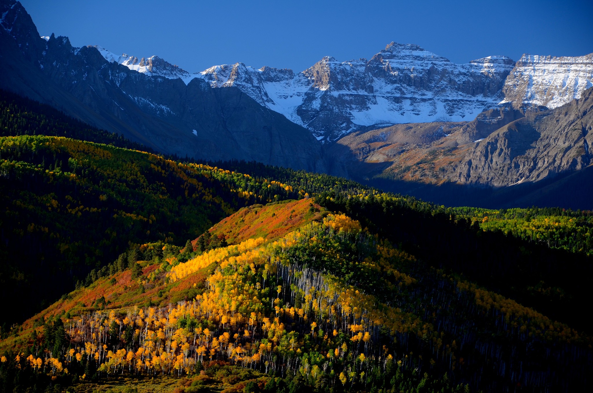
- Million Dollar Highway, Colorado. This refers to the 82-mile stretch of US 550 between Ridgway and Durango in southwestern Colorado. It will take you into the heart of the San Juan Mountains, where you’ll keep company with several 14,000-foot summits and cross three passes over 10,000 feet. It’s a wonderful drive most of the year. But what really makes it special is this: It’s arguably the best fall foliage drive in the western United States!
The road is fine for cars, RVs and motorcycles. You’ll find services in Ouray and Silverton. There are plenty of turnouts for photographers. Nearest airports are Denver and Albuquerque (both are a considerable distance).
Foliage displays happen on their own schedule – earlier one year and later the next. For the San Juans, your best bet is to be there between September 25 and October 1. Don’t worry about days of the week. This is too far from Denver for traffic to spike on weekends. Traffic never gets heavy, but you’ll find lots of tripod-toting photographers in the best shooting locations. Some of these people have photo equipment that cost more than my house.
You’ll want to drive from north to south. The sun is in the south sky in October, and foliage looks best when it’s backlit. Spend the night in the funky old mining town of Ouray. Start your day early by detouring west a few miles on SR 62 to the Dallas Divide. You’ll probably find 50 other photographers there waiting to capture the dawn on 14,110-foot Mt. Sneffels. Back on US 550, as you pass Ouray, you’ll start to climb. And climb. At Red Mountain, you’ll see an entire mountainside of golden aspens, reflected in a mining pond. The shore of the pond is tripod city. Of course, western fall foliage is mostly yellow – aspens on the high slopes and cottonwoods in the valley bottoms. Both are spectacular. Fall isn’t the only time to drive this road. It’s plowed in winter, and looks great any time of year.
While you’re in the area, here are a few options. One is the highly popular Silverton train out of Durango. Another: Take a jeep tour out of Ouray to some of the old mines and ghost towns of the San Juans. Third, Mesa Verde National Park is an hour to the west of Durango off US 160. And fourth, the canyons and mesas of southeastern Utah are just a few hours away.